
|
It was after sunset and I had just arrived home from a long day storm chasing in Co. Donegal with Nigel McFarland when I intended on winding down for the night. I was tired but also buzzing from our chase and I knew from a casual glance at the models while on the road home that there was another chance of storms the following day however I decided to hold back until I got settled for a deeper look. By the time I had recharged all my DSLR and drone batteries and got my images and footage off loaded onto an external hard drive it was already midnight. Even though my thoughts were entirely on storms I noticed it was clear outside so I took a quick look out the back high into the east and did a visual inspection of Corona Borealis, there was no sign of a new star in the SE quadrant of that constellation so TCrB hadn't erupted yet, the night sky was behaving itself and all was well.
Feeling relaxed I set the lap top on my lap and did a catch up on social media then had a look at the models, was there still potential for tomorrow?, first of all I checked our facebook group called Ireland/NI Storm Chasers and immediately noticed that Owain Rice had issued a convective outlook for the 21st. Owain's assessment of the synoptic situation was superb as always and the forecast included a yellow and orange risk box, it was time to take a deeper look. Various models all agreed on moderate instability with CAPE values between 1000-1500j/kg with LIs of -2 on a moist unstable warm sector flow with cloud tops in the -40c to -50c range. Deep layer shear was extremely weak so storms looked to be pulsey in nature however there was up to 20 knots of low level shear which could just be enough to help with brief multicell modes in the strongest storms. A widespread convergence zone was set-up across central and west central areas with the latter looking most pronounced, however this convergence zone (Cz) would migrate eastward through the afternoon and evening.
The set-up looked really good however I did have some concerns despite these positive ingredients. First of all cloud cover could be an issue, there's nothing I despise more than a chase day under grey clouds, they don't always work out when you need solar heating as a primary source of lift, however we did have the Cz to fall back on to give extra support. My main concern was the precip, the AROME (yes I'm slightly biased by this model) was showing a very messy scene with showery rain over the west midlands where our main target area would be, in fact, it looked more like a showery frontal mess than anything else and I really didn't like it at all. As I clicked through the hours on the AROME it did show that mess breaking up with more isolated cells over the Tyrone area and even along the west side of Lough Neagh, however I didn't give these too much thought as the Cz and overlap of strongest CAPE looked to be in the west, especially the Omagh and Fermanagh areas. So the plan was to get on that mess and hope for storms then chase eastward later if needed.
To be completely honest with you I was not liking this set-up at all, I felt it could be a bust day or else a few rumbles and nothing photogenic at all. Then I got a message from Owain Rice, he was very interested in chasing and wanted to hook up with me for the day. I was delighted to get the message because for the better part of a year or more we chatted about the prospect of going chasing together, we actually had a few days planned during the epic 2023 season but due to one thing or another the plans fell through. Earlier in the week I did say to Owain that I promised we were going to meet up this season, and I meant it. However I didn't expect it to happen so soon, firstly I was surprised and a little anxious because I didn't want Owain's first chase with us to be a damp squib, the last thing we needed were grey skies and nothing photogenic, we needed something dramatic to get the chase off to a memorable start. Then I thought to myself, wait a minute, if Owain actually wants to chase today then he must have high confidence of something cool happening otherwise he wouldn't want to be there, this logic raised my hopes for the day.
For those of you who don't know, Owain Rice is our forecaster on the facebook group I mentioned above. UK/Ireland had/does have great forecasters over the years which we always relied on for quality such as Paul Knightly from TORRO, Dan Holley from Convective Weather, ESTOFEX, Nick Finnis from Netweather.tv and Tony Gilbert from UKweatherworld, these guys are amazing forecasters. All of these forecasters do this in their spare time and don't get paid for it so their services are greatly appreciated by us chasers. However in recent years there has been a decline in forecasts, much to our despair Dan had to step down from CW and Tony no longer covers Ireland anymore. We felt that Ireland/N. Ireland was really suffering for regular forecasts, there was a gap which really needed filling, but who would be up to the challenge?
I dabble in forecasting myself however I am by no means an expert, I know enough to get buy but I wouldn't classify myself at a high enough standard for issuing public forecasts other than posts on my own social media which are experimental and for fun. During the last couple of years Owain and I had been conversing about our passion for storms and it became very apparent to me that Owain was extremely knowledgeable on the subject, in fact, more so than anyone else I know. Before chase days Owain would send over his home made outlooks via messenger, then this evolved into risk maps, all of this was strictly private between us both. I can tell you I was extremely impressed by his technical prowess and decided these were too good to be hidden from the public. I hinted that his work deserved more attention and he should start posting in public, and that was when he decided to start Ireland/NI Storm chasers on facebook.
This page would be used to post our images and reports but more so it would be a place for Owain to share his forecasts to fill that much needed gap to meticulously cover Ireland and N. Ireland, and the rest is history. Anyone on the page who has read Owain's outlooks will agree that they are the finest convective forecasts we have come to see in recent years, the level of detail and accuracy is quite remarkable and up there with the best, due to these outlooks we have been able to fine tune our chase targets and increase our chances of success for photography, so this meet up between Owain and I (and others later) would be another moment in Ireland/UK storm chasing history.
That night I didn't sleep until the early hours of the morning, then by 08.00 I was awake and sharp, all I could think about were storms. I packed all the gear into the van, washed the windows, had breakfast, then Rhua and I hit the road. Before 11.00 Owain arrived and even though we had never met in person before there was no awkwardness as the conversation immediately turned to the sky and storms, radar, satellite imagery and the overall set-up for the day. We drove back SW as quickly as we could and soon we where on the Cookstown-Omagh road, one of my favourite locations for chasing, it was good to finally show Owain the general area after years of talking about it. Over an hour later we made it through Omagh, the traffic was fine, then ascended a mountain in the area called Pigeon Top, a location chaser Paul Martin introduced me to many years earlier.
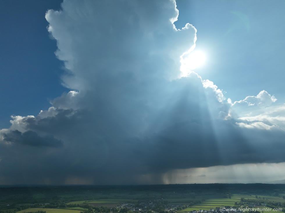
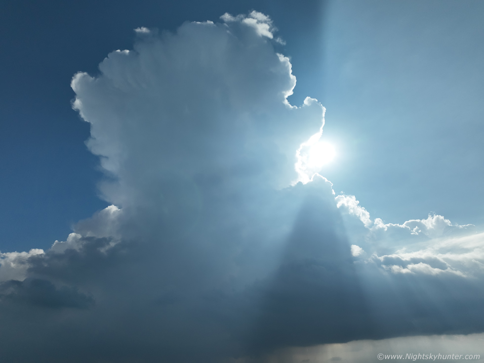
The view from Pigeon top was great, we found a lay by then got out to watch the sky, from here on it was a waiting game. This was a strategic position on the convergence zone where the best parameters overlapped and where precip models were showing strong cores later, it was also inside the amber risk box as per the forecast. The sky wasn't inspiring to be honest with grey mid level cloud and horizon haze obscuring anything of interest and as time went on the cloud got thicker and it got colder, to be honest I wasn't feeling this at all, there was little to no solar heating, but I tried to remain optimistic. To pass the time we got our gear prepared, which for me wasn't a big task, I had my drone bag and DSLRs all in their bags in the back of the van with doors open ready to grab, all the cameras were adjusted for daytime settings to save time and I had the 100-400mm lens on my 600D in case of a surprise funnel.
We all have our own goals when it comes to chasing, for some its the photogenic potential, for others its the visual experience, thrill of the chase, the road trip, or simply a reason to get out and enjoy nature. Owain is really into his video and audio, his passion is getting real time long video sequences combined with clear audio to record thunder and any related ambient sounds to compliment the footage. For this he had stereo microphones on a bracket on top of his camcorder, all tripod mounted, it was a good set-up, he admitted he had purchased these new mics recently and wanted to test them out in the field so that was one of his primary goals, I hoped he would get a chance to achieve that goal this day. The sky was still grey but seemed to be slowly building and getting more agitated, we filmed a short vlog then got back to sky watching, we could see distant towers and a long base emerging from the haze on the horizon and even the mid level cloud was starting to look convective, it seemed low levels and mid levels were convecting in unison which was a good sign.
Owain estimated that based on models and radar that we should be hearing thunder around 2pm, in fact, radar showed big cores below the border, some already producing active lightning and that area of interest was slowly moving north. Then I got a call from Nigel McFarland, he was battling dense traffic in Strabane but was making good progress, he would be with us soon. It was only yesterday that Nigel and I had been chasing in Donegal which now seemed like a dream as one storm day had now blended into another. Nigel arrived, assessed the situation, he realized that a hill to our south was blocking the advancing area of interest, he had spotted a better location down the hill which offered a decent view which looked across wind turbines so we re-located to that position.
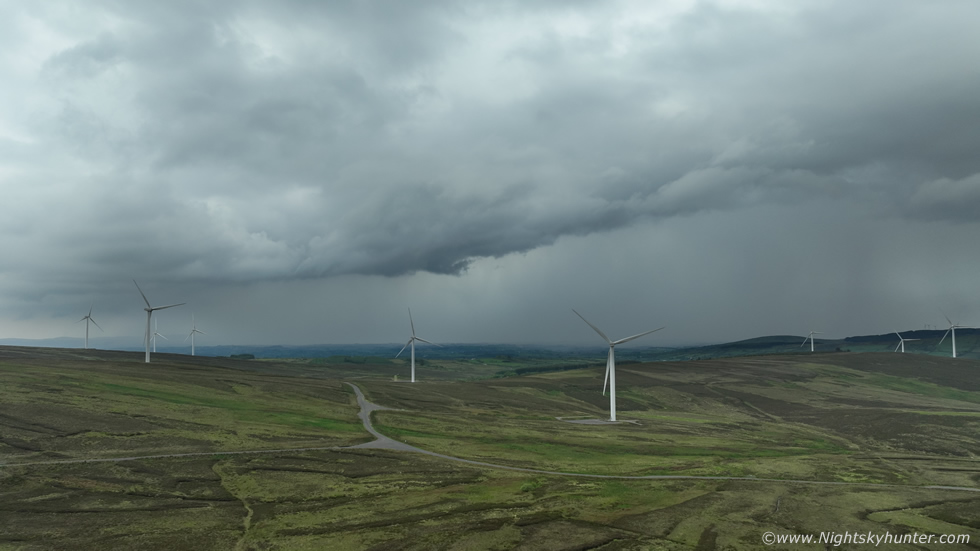 |
The view was excellent to the south and southwest with turbines all over the area which added to foreground interest, then we heard thunder booming across the landscape, then a few minutes later another rumble, the storms had arrived and it was 2pm, Owain was bang on with his forecast almost to the minute. All three of us were shooting, two video cameras and Nigel had the lightning trigger ready, we excitedly talked about the prospect of getting a c-g striking a wind turbine, this was a very real possibility, if it did it would be a stunning photo opportunity. We watched and waited with great anticipation, but nothing, there was no more thunder, in fact, the clouds looked entirely outflow dominant. The sky was dull and grey and the growing wind was cold, it felt like Autumn, to be honest it was horrible.
However not one for admitting defeat we remained committed, we still felt that one last bolt was possible anytime, it had happened in these situations before. I got the drone in the air for a few images and video sequences then decided it was just a waste of battery and landed. These storms were now spent, we had gave them every chance we could and now was the time to move on, it was that cold we had coats on, this was not how a Spring chase day should feel. We looked to the east and observed sunshine and blue skies, radar showed a massive wet mass approaching us and to our west over Fermanagh so our only option now was to stay east and get back into the sun and hope that solar heating would trigger something in that area. We drove across Pigeon Top and began our descent down the other side, we entered sunshine and immediately felt warm again, then a big solid updraught arrived into view and it looked like the real deal, it was located just outside Omagh town so this became our next target.
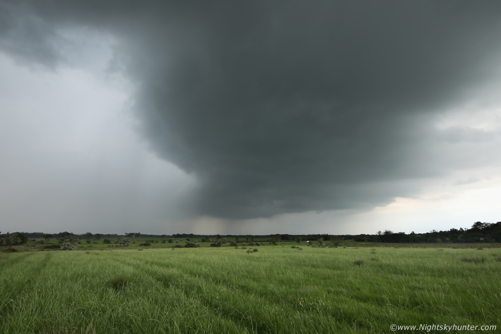 |
Back on ground level we were in a different mental state, the polar opposite of earlier, we were excited and back in full chase mode, that updraught we spotted was close by the town and visible through the window to our right was a menacing large storm base which looked very dark, scud tags could be seen rising into the base and the formation looked very low, it was the best looking sight all day and our first chance of structure, we knew it was fully capable of producing a large funnel cloud, it just had that look. TORRO even posted on social media about the convergence and funnel/tornado risk in this area which ramped up the excitement even more.
Our drive through town was restrictive with buildings and trees blocking the view, we could only get brief glimpses, we were mad looking to get into open countryside. Unknown to us at the time this was a very active thunderstorm producing regular lightning while we drove through Omagh. Eventually we cleared the town back onto the Omagh road, the cell looked to be coming our way and now had a large precip core, our time was limited to get a view of the base as the precip would arrive soon. We blindly took a narrow back road off the main into the countryside, again surrounded by trees and hedges, however we found a gap in the hedge and a gate to a field which offered us an opportunity so we pulled in for a quick look even though both our cars were blocking this small road. I grabbed the DSLR, jumped over the gate and ran into this field, at last a non-cluttered view of the storm. This is 15mm wide angle on full frame showing the impressive updraught base, it was a very big solid base, then flash and a big rumble of thunder at close range. I looked back and saw Owain filming then saw Nigel drive away on the chase, I suspected he was moving to a better position. Another loud angry rumble then the core hit us, we ran back to the van and began driving along a narrow twisting back road.
We cleared the core again for a brief moment and stopped again to film, the storm was rite beside us and we where in the danger zone, it felt like a bolt could hit at any moment, we really were taking our chances. This was when we noticed clouds along the periphery of the base churning, rising, and rotating, something was happening and we needed a far better view as we where in the trees again. We spotted turbines on a hill so began to drive in that direction, a steep ascent, then narrow roads which looked more like a tractor path with big pot holes in the ground and eventually the road vanished from my sat nav, it just ceased to exist on there. We made it to the top, it was still raining and the clouds were still exhibiting rotation but it was obvious the cell was dying in classic pulse fashion. I wondered where Nigel was then saw his car coming into view, he had the exact same idea and had approached from the other side, great minds think alike. The view was fantastic from here, we made a note of it for future chases, we christened it 'Bob's Road' (Twister reference).
We went back to low ground again and continued along the Omagh road, random cells were popping up on radar, we ended up driving through the core of one of these and it was quite impressive. Rain so loud we couldn't hear each other, wipers at full speed not clearing the windscreen, water logged roads, flash flooding along the side and horrendous viability, we were loving it. We got ahead of the core and pulled over, a nice gust front feature had formed on the leading edge but we where too close so we drove further east along the road and stopped again for a look, this time the feature had gone and there was nothing left to shoot. At this stage we badly needed a new plan, we were getting frustrated at the lack of photo opportunities, Nigel was getting annoyed at all this stopping and starting and I was getting tired. Honestly, I was fairly certain at this point that aside from a few more single cell storms the day was nearly done, they were too pusley and dying fast and didn't offer much on camera (except the Omagh base) so I was starting to loose hope.
Nigel showed me the radar, red cores had formed to the south and southwest of Lough Neagh and where slowly moving north, my optimism was starting to wane at this point and Nigel saw it, I said yes but they would likely die out quickly just like the others. Nigel said it was our only play so we decided to go for it, I was happy enough to get back into warm sunshine anyway, as we drove on I said to Owain ''five o'clock magic'' (USA chase phrase). Meanwhile Colleen Webb rang, she had just finished work and was out chasing, she was in the Lough Fea area and was changing location to Ballyronan Marina, we communicated this to Nigel so that become our new plan. At this stage my mindset was the following, we were likely not getting any more storms and likely no photo opportunities, but on the other hand it would be a good chance to show Owain Ballyronan and for Colleen to meet Owain too so it would be a nice place to end the day and a much needed rest too.
As we drove between Moneymore and Ballyronan we saw interesting convection, very crisp and agitated, however it didn't look like it was going to do much, we also noted small towers leaning over, Owain said this was likely due to the low level shear, this observation would become important soon. We arrived at Ballyronan Marina in perfect weather, the sky was blue, the sun was hot, ducks and swans did their thing on the little beach, it was a pleasant moment after all the hectic driving. We got outside to stretch our legs, Colleen got to meet Owain and I finally got to finish my sandwich (I needed the energy). After a little storm chat we noticed a very large updraught tower behind us visible above the trees and another white cell further down the lough, suddenly the air was full of hope again, everyone grabbed their gear and we made our way along the shore to the new look out point.
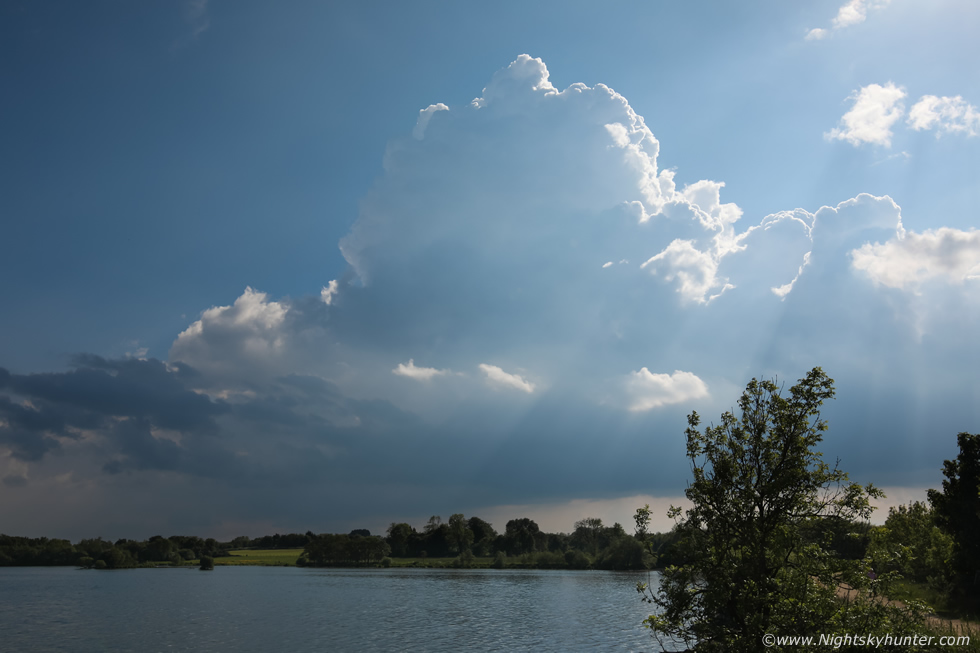 |
All four of us stood on the look out point with our gear set-up, I'm sure passing walkers were wondering what was going on. Conditions felt perfect, solar heating was strong and that tower was growing rapidly, in fact, we all agreed we were expecting a rumble at any moment. Further away was the other cell, we could hear distant thunder from it, that was the one which had passed to the east of Dungannon. I got chatting to a lady who was observing what we were doing, I explained we were watching for storms and she was very interested, I pointed out the towering cumulus to her and said we were hoping for thunder from that soon. A few minutes later thunder rumbled from that very tower, we were all ecstatic, we now had two storms in view but this one was quickly dominating the atmosphere. More thunder rumbled, there was little in the way of precip at this stage yet it was already producing lightning and at first I thought it was going to do the same thing as the others and die soon, but it didn't, it was getting more active and stronger by the minute, this storm was a different entity entirely, I checked the time, just after five pm, five o'clock magic indeed!
 |
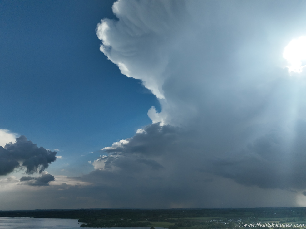
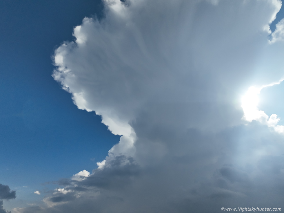
The updraught plume exploded skyward, we could see the edges of the updraught moving by the second with rock hard edges and within what seemed like a few minutes it was already massive in the sky. I got the drone in the air for a look, this is full wide angle and I struggled to fit it in the frame already. The high sun was back-lighting the storm sending sun beams fanning down in all directions which made for an exceptionally atmospheric sight.
 |
The time between these two images was less than eight minutes, the precip core turned heavy and dark and the updraught just went nuts as it began to anvil out over our location while at the same time producing deep rumbles of thunder. Everyone was in their zone enjoying every moment of the storm while also being fixated with their own camera gear and the task of recording the moment.
 |
Maximum vertical tilt of the Mavic 3 Classic drone camera, it would soon expand beyond the field of view, I also noticed the sun would soon get eclipsed by the growing anvil which would be a cool moment to capture.
 |
Now an enormous storm and the anvil kept getting better and better as it spread out, the edges were absolutely rock solid, I was kind of shocked as I wasn't expecting anything of this calibre today. Roisin was texting me to say she was hearing thunder from Cookstown, then more thunder and again more, of course what she was hearing was the very same storm we were watching.
 |
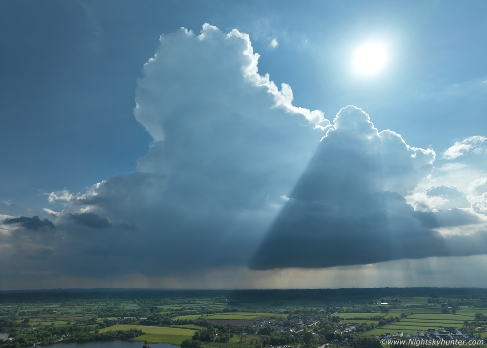
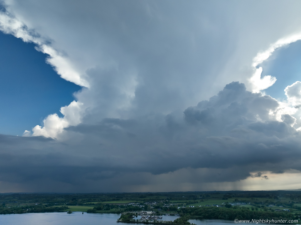
This is what the sky looked like over our heads, stunning symmetrical anvil going up into the sky like a volcanic plume, the anvil had solid knuckles around the edges and fine cirrus streamers swept directly under the incus. We stood in disbelief as thunder rumbled from this thing, in fact, it was really obvious that much of the lightning was intra-cloud from inside the updraught and especially from high up inside the anvil. The thunder actually sounded like it was descending from a great height, this reminded me of some of the epic storms we experienced last year. The crepuscular rays fanning downwards and upwards against the blue sky also added to the the beauty of the storm.
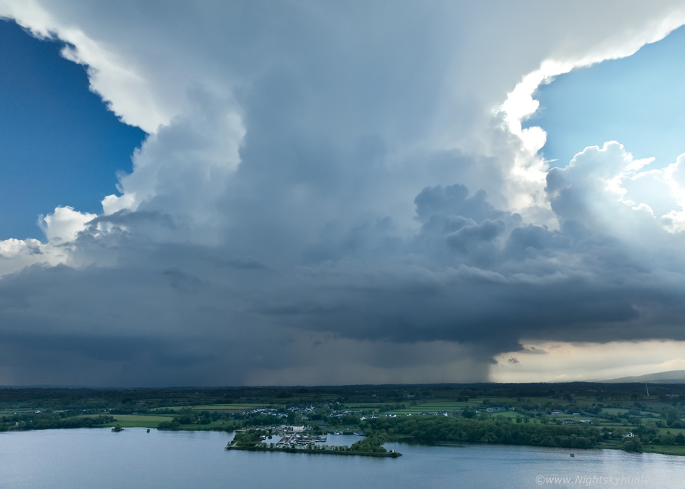 |
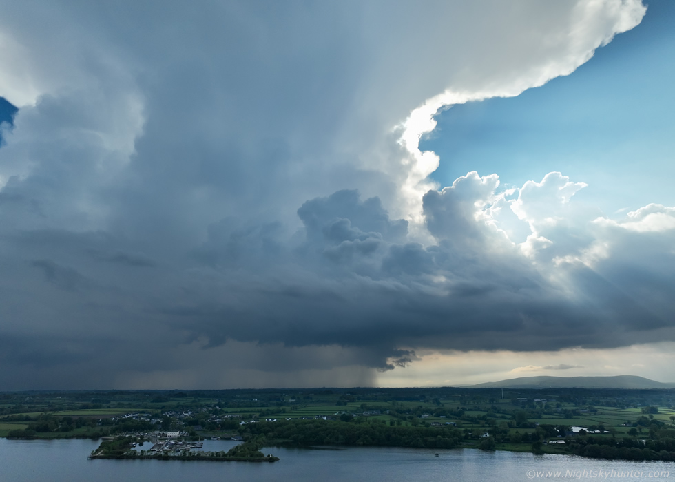
Panning drone camera straight down to reveal the base. I wanted structure and now I had it, this was a beautiful storm with strong cores and even a compact flanking line visible with new towers building into the main updraught, this was actually borderline organized for a time. To get a sense of scale check out the large white building at the Marina and compare that to the size of the storm.
 |
The anvil continued to spread out producing thunder the entire time, I didn't know what to be doing so I let the drone record video while I took hand held phone video complimented with DSLR images. Colleen had her drone in the air too while shooting with her DSLR and phone, Owain had his Go Pro, video camera with mics recording and phone, Nigel had his DSLR with trigger and phone recording so at some stage there were eleven devices recording this storm. We were all buzzing with excited chat, someone said John Fagan had been in touch through messenger asking where we were, Owain jokingly said ''look for the huge nuke, we are below that''. He was rite, the top did look like a mushroom cloud, anyone who looked at the sky at all would have seen this anvil for miles in all directions.
 |
We had one sublime moment, the anvil thunder was so cool that we all went completely silent for several minutes, all we could hear was the gentle lapping of the water on the lough and anvil thunder rolling one after the other, it was complete bliss and a moment I will never forget.
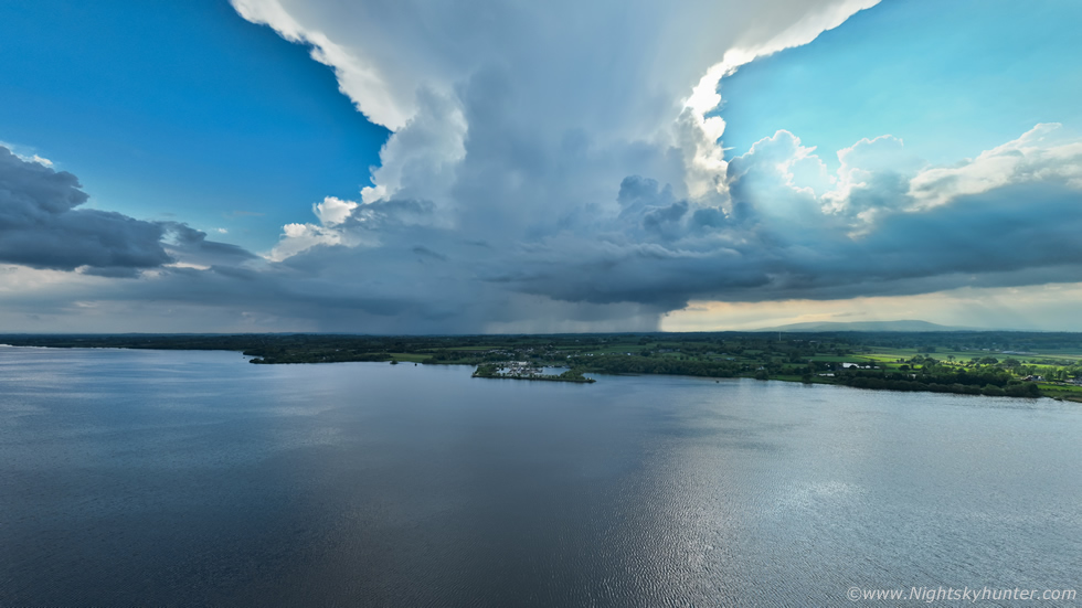 |
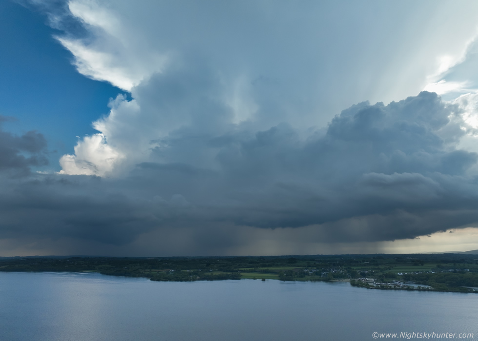
The entire storm was impossible to get in the frame, this was a wide angle pano with the drone, I don't know if the image works or not as the top was cut off, however I do think it provides a great sense of scale to show how large the storm was in relation to the side of the lough. It actually does look a bit like a volcanic eruption!
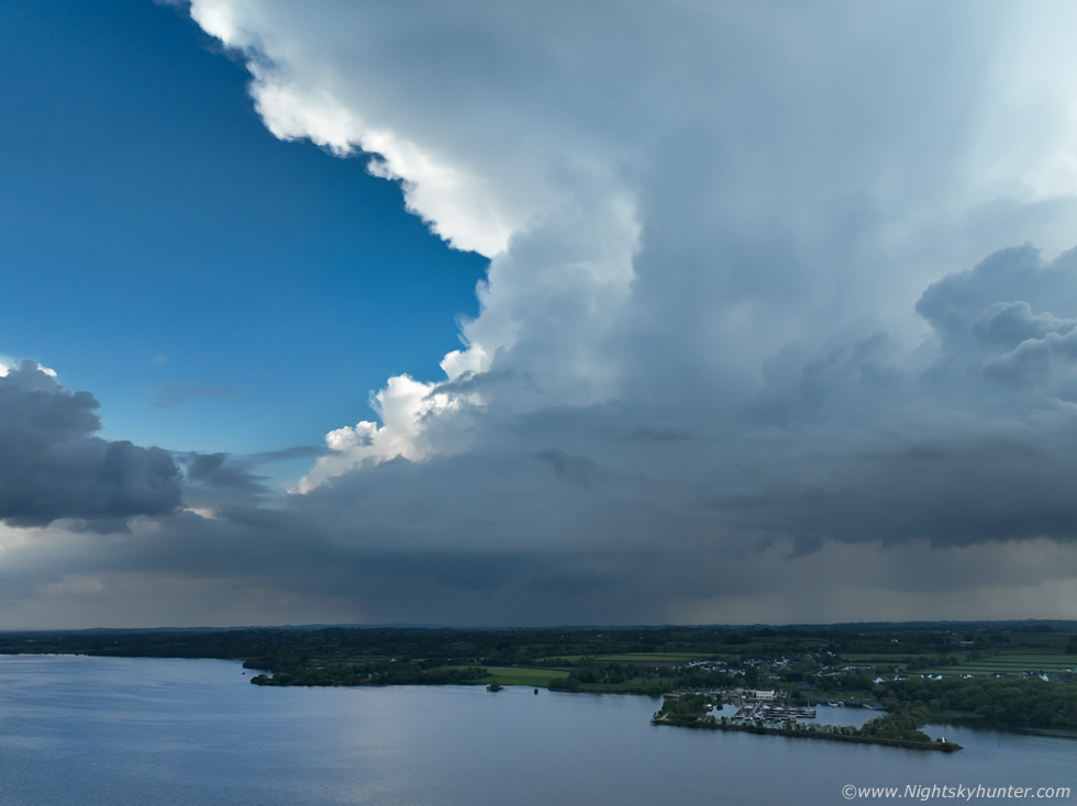 |
Flanking region feeding up into the principle updraught and anvil interface, it almost had an LP look about it here, likey due to the low level shear which Owain noticed when we first arrived, that was enough for basic tilting of the lower regions which helped this storm last for so long, it even had developed transient multicell traits.
 |
We all moved on from our moment of zen and were back talking in an excited fashion and discussing every aspect of the storm, it was fair to say we were all on a natural high. Owain had got his audio of the thunder so that was his goal achieved, the only thing missing was a big c-g. Charts indicated that several c-gs had struck however they must have been hidden inside the dense precip core or struck on the other side. Owain was still recording video, he said he was hoping for a bolt from the blue, a large clear air positive bolt, a ''house shaker!'' as he called it (that's official terminology by the way).
 |
The storm had been producing thunder for an hour, I now wonder what it must have looked like from the west side, from there the entire storm would have been lit brightly in full sunshine and likely a spectacular sight. This single storm not only made our day but made our season so far, it was the perfect scenario which I love, standing in warm sunshine watching beautiful storm clouds rumble with not a drop of rain us, perfect visual and camera friendly conditions which don't happen too often.
What made this moment even more special was the fact that this was Owain's first storm chase with us so we couldn't have asked for a better storm which exceeded all our expectations and for it to happen at the climax of the day. We appreciated this moment even more when placed in the context with our earlier storms. To go from cold wind, grey skies, heavy rain, mad rushing around, many miles driving, then to suddenly get presented by this was beyond rewarding, it felt like we had earned this storm and mother nature acknowledged this by giving us something special.
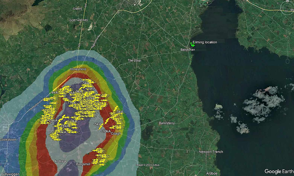 |
Thanks to Owain Rice for creating this graphic showing our observing location, radar and sferic plots. This storm ended up producing over 340 in-cloud bolts!, it was located just inland along the west side of the lough between Cookstown, Moneymore and Coagh, I'd say the view from Slieve Gallion must have been impressive.
This surely had to have been the best thunderstorm of the day not just for lightning frequency but for its light and structure, the storm was isolated and exploded aloft in uncontaminated air taking maximum advantage of untouched instability combined with very strong solar heating and surface convergence, in fact, soundings showed this storm had fed on more than 1000j/kg of CAPE. This underscores the importance of never ever giving up and also shows that one should never pass up on days with weak shear, or no strong speed shear aloft, anything is possible on a storm day. We then watched the storm slowly die with anvil forming into weak mammatus, we had observed its entire life cycle, it was then that we called an end to the day. I left Owain back at the bus station and he made his way home to Co. Down, I'm sure he was feeling as happy and content as we did. I'm still buzzing as I write this now.
Vlog and footage from the chase featuring Omagh then the Ballyronan storm with drone footage which I hope does the day justice. Our storms have been getting more intense in recent years, during 2023 I've heard the word 'continental' being used to describe our storms and on this day Owain used the word 'tropical' for the Ballyronan storm, it makes you wonder what other atmospheric surprises await us this season. Thanks very much for reading.
Martin McKenna